This was not a usual U3A walk, as there were only 3 of us and it took place on a Saturday. However, I've included it here as we were all members at the time. That's Lene, Ian and myself.
We left early on Saturday for the drive down towards Strathgordon, and the weather was perfect. When it's perfect in the southwest, it's REALLY perfect!
We found the car park at the Mt. Wedge Nature Walk without problem. The Nature Walk itself is very over grown and you can just see some of the metal signs lurking in the bush. As soon as we started on the track, it was blocked by a very large tree.
 |
| Car Park |
 |
| The log |
 |
| Narrow track |
 |
| First sight of Mt.Wedge |
 |
| Large Gum |
 |
| Off to side of track |
 |
| Interesting open area |
After climbing over this we had a walk through fairly level bush until we reached a forestry road. Left on that for a short distance and we picked up the track to the top of Mt. Wedge. In places the track was very narrow, but we found it had been well marked with tape.
You get a variety of bush on the way up, from scrubby and overgrown to open, green and mossy. Finally you get to the point where the first view over Lake Gordon appears.
 |
| First view of Lake Gordon |
 |
| The Sentinel Range (I think) |
 |
| Track disappears again |
 |
| Not the top, but the rocky outcrop and we go to the left, around and up. |
 |
| The Sentinels |
 |
| Looking from bottom of rocky outcrop |
 |
| Lake Gordon |
 |
| Up to first plateau, Ian & Lene just up the track |
Continuing up, the track gets steeper and zig zags in places until you reach open, rocky ground. It then skirts around a large stone outcrop, and you think you're nearly there. Wrong. I think there were about 2 plateaus before you get a view of the ultimate top.
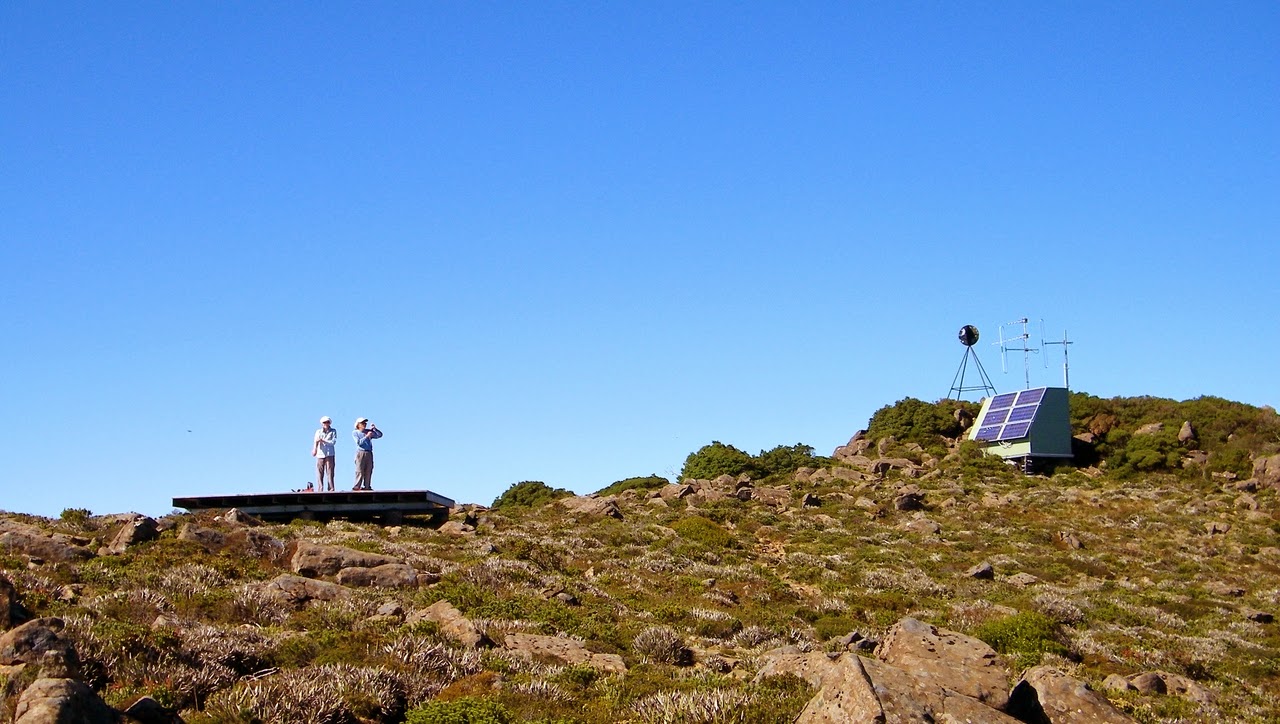
On top there is a small shack with radio relay equipment and a little distance away, a wooden helicopter platform. This forms a good spot for lunch and just admiring the views. Did I mention the weather was perfect?
 |
| Mt. Wedge peak |
 |
| We had to look at views like this with lunch |
 |
| Photo by Ian |
 |
| Photo by Ian |
Finally it's time to start down. Shortly after leaving the top, 2 blokes appeared in front of us. No equipment, just wanted to get to the summit. I think they were tourists from the U.K. After leaving them we found one of their wives sitting on a rock near the outcrop I mentioned above. She hadn't wanted to go any further, so she was left there. Very glad to see us, she tagged along back down, when the other 2 caught up with us near the logging road.
On another day, that could have been an accident waiting to happen. I don't think they realize how far they are from any where if anything occurs.
We continued at our own pace, and walked around the other side of the Nature Trail, back to the car.
After lots of stretching, we made our way back to Kingston. It was a great day.
I used to travel to Strathgordon years ago when the dam was being built, on an unpaved road in a Mini Van. I wonder how a nation such as the U.K., which has it's fair amount of rainfall, could build a vehicle that was so susceptible to running on 3 cylinders in wet conditions? Ah well.
We had 3 walkers and covered 8.22km in 6:46
Click here to download GPX file


